India is developing an early warning system for landslides that would help save lives and prevent damage to property, Parliament was told last week. The system, dubbed LEWS, is being tested by the Geological Survey of India in the two hilly districts of Darjeeling in West Bengal and Nilgiris in Tamil Nadu, and is likely to be operational by 2025, the earth sciences ministry informed the Rajya Sabha.
The prototype regional Landslide Early Warning System (LEWS), being developed by the Geological Survey in collaboration with its British counterpart under the aegis of the National Environmental Research Council’s LANDSLIP project, is based on rainfall thresholds since 2017.
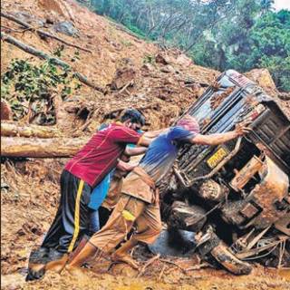
There has been increasing incidence of landslides in the country, particularly due to excessive rainfall during the monsoon season in Kerala, Uttarakhand and Maharashtra.
In response to a question on the number of people killed during the monsoon floods this year, the home ministry said: “This ministry does not maintain the centralised data regarding loss of human lives and crops due to any calamity. However, state-wise details of the human lives lost and loss of crops due to hydro-meteorological calamities, including floods, landslides, during the year 2021-22, as assessed/ reported by the state governments/ Union territories.”
As per data shared by states and UTs, 2002 persons were killed in cyclonic storms/ heavy rains/ floods/ landslides in 2021-22 and crop area of 50.40 lakh ha was damaged.
The LANDSLIP project developed a prototype last year based on terrain-specific rainfall thresholds in the two test areas. Since the 2020 southwest monsoon, the Geological Survey has started issuing daily landslide forecasts during the summer monsoon to district administrations in Darjeeling and Nilgiris, the central government said.
GSI has also laid the groundwork to develop regional LEWS in other landslide-prone states like Uttarakhand, Kerala, Sikkim from this year and plans to add five more – Himachal Pradesh, Karnataka, Assam, Meghalaya and Mizoram – by 2022.
“The evaluation and calibration of the models will continue during the next few monsoon years and the regional LEWS will be made operational in phases in all such 10 states, the earth sciences ministry told Parliament.
India’s National Disaster Management Authority has also constituted a group that includes the National Institute of Hydrology, Indian space Research Organisation, Geological Survey of India and Wadia Institute of Himalayan Geology, among others, to develop a monitoring and early warning system for rock and snow avalanche events including glacier and landslide lake outburst floods to reduce cascading impacts like flash floods and landslides in downstream areas. The authority released guidelines on management of such floods and a summary for policy makers on October 13.
India currently does not have an early warning system for glacier-related disasters but has conducted studies on their melting by assessing mass balance studies and monitoring the recession of selected Himalayan glaciers, which have been receding due to global warming.
In a response to another question on increasing lightning deaths on December 1, the earth sciences ministry told the Lok Sabha that lightning activity has shown an increasing trend in the past two decades.
“Northeast, east and parts of peninsular India have registered a sharp increase of lighting over the past two decades, the miniostry said in its response. As many as 2,357 persons died due to lightning strikes in 2018, it said. The number was 2,876 in 2019, and 2,862 in 2020.
Rainfall patterns in many parts of country has also been changing, partly due to climate change. There is an increasing trend of heavy rainfall events over Saurashtra and Kutch, southeastern Rajasthan, northern Tamil Nadu, northern Andhra Pradesh, southwest Odisha, Chhattisgarh, southwest Madhya Pradesh, West Bengal, Manipur, Mizoram, Konkan, Goa and Uttarakhand, the ministry told the Lok Sabha on December 1.
The India Meteorological Department has carried out an analysis of observed monsoon rainfall variability in all states. Five states – Uttar Pradesh, Bihar, West Bengal, Meghalaya and Nagaland – have shown significant decreasing trends in southwest monsoon rainfall between 1989 and 2018, the weather office found.
“It is possible to develop an early warning system for landslides. In Uttarakhand, we have a proposal where landslides or avalanches can be mapped through a careful study of geology, faults, folds, thrusts, curvature, slope, magnitude of slope, vegetation cover, seismicity, etc, which can help us identify a large susceptibility zone. From IMD, we can get rainfall data and forecast for automatic weather station network and use artificial intelligence for quick decision making. An early warning system can be created which gives people 20 minutes time to evacuate. People should also respond to such a system, then it can be successful,” Kalachand Sain, director, Wadia Institute of Himalayan Geology, said.
Sign on to read the HT ePaper epaper.hindustantimes.com