LUCKNOW Uttar Pradesh recorded above average post-monsoon rains in the last 48 hours caused by western disturbances and cyclonic trough, which had affected daily life in several districts including Lucknow.
As per the data of the IMD, the state received an average of 80mm rainfall between October 1 and 19, which was 178% more than the normal 29mm rainfall expected during this period.
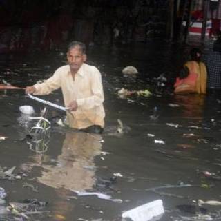
The state capital recorded over 300% more rains than normal in the last 48 hours. The showers accompanied with strong winds came in spells on Monday afternoon followed by continuous drizzle on Tuesday. Trees were uprooted and power supply remained disrupted due to the inclement weather, which also caused water-logging leading to traffic snarls in various parts of the city.
Besides Lucknow, 34 districts across the northern parts of the state received above average rainfall in the last 48 hours, according to rain statistics of the Indian Metrological Department (IMD).
“The rains and strong winds in the last two days were caused by western disturbances and a low cyclonic pressure above the state. The atmospheric conditions are expected to subside after Wednesday,” said JP Gupta, director, state MeT department.
The heavy showers also brought down temperatures across UP. The minimum temperature stayed near the 20 degrees Celsius mark in Lucknow while the maximum hovered around 27 degrees in the last two days. The MeT department issued a similar forecast for Lucknow till Thursday.
The rains alarmed Kharif cultivators who were planning to harvest their produce from this week. “The farmers will have to delay harvest for at least a week now. The rain will cause more damage to the farmers who have harvested their crops, but have failed to store or sell,” said agriculture economist Dharmendra Singh.
Sign on to read the HT ePaper epaper.hindustantimes.com